Home away from home for hillwalkers and ramblers who happen to work together in a building in Glendale (and their family, friends and fellow ramblers). See the BR Event Calendar for upcoming hikes

November 26, 2008

Mt Lukens - Highest Point in LA City Limits

Stone Canyon to Mt. Lukens hike
The Brand Ramblers hike Saturday December 6 to the highest point in Los Angeles city limits, Mt. Lukens at 5074 feet.

  • Start Time: 7:30 AM, Saturday 12/6
  • Trailhead: Wildwood Picnic Area in the Angeles National Forest (6 miles up Big Tujunga Canyon road from Sunland).
  • Duration: Approximately 4-5 hours
  • Distance: 8.5 Miles
  • Elevation Gain: 3200 feet
  • Total Elevation: 5074 feet
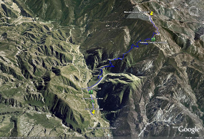
Brand Ramblers Google map for the Mt. Lukens hike

Checklist:
  • Assemble at 7:30 AM at the Wildwood Picnic area. Plan to arrive early so we can start the trek on time. Cell phone reception in the Big Tujunga wash is terrible so you should not expect to call ahead about running late. Give yourself some extra time - you can use it to warm up and stretch before the hike.
  • All cars will need a Angeles National Forest Adventure pass (either a day pass or annual pass). Day passes are $5 and Ken will be picking up passes at the Big 5 sporting goods store in Glendale on Friday - just let him know if you need one before noon Friday.
  • To reach the Stone Canyon trail we need to cross the Big Tujunga creek which usually entails wading across. Removing your foot gear and rolling up pants works well but you might want to wear shorts to make this easier. Some Bramblers may bring trekking poles and these can be shared for the crossing.
  • Gear: Good hiking shoes, hats, sun glasses, trek poles, etc. and dress in layers as it is expected to be chilly in the morning and warming up later in the morning.
  • Food & Water: Bring at least 1-2 liters of water and some snack food. The usual suspects will be bringing extra snacks including smoked sausages to share.
  • Car Pooling: Confirm your attendance by contacting Ken before Friday afternoon. If we can carpool we can save on the Adventure Passes and at least one USC area Brambler still needs a ride.

Some reviews of the hike:
LocalHikes.com
ModernHiker blog

November 25, 2008

Mt. Baldy Sets New 'Bramblers' Records

At the summit: standing left to right: Paul, Ryan, Tina, and Sun; kneeling in front, left to right, Mark and Ken
Early on Saturday November 22, 6 ramblers assembled at Manker Flats for an ascent of Mt. Baldy via the 'ski hut' trail and a return across the Devil's backbone. The 12 mile roundtrip include a punishing 4K foot climb to the summit.

Left to right: Paul, Mark, Ken, Ryan, Tina, and Sun assembled and ready to head up the 'ski hut' trail to Mt. Baldy some 4000 feet above
This was the long planned ascent of Mt. Baldy and established a number of firsts for the Brand Ramblers: highest elevation (10054'); most elevation gain (3900'); longest distance (12 miles) and longest duration (6 hours).

Ken, Mark, and Sun posed on the trail below the ski hut
What a gorgeous day! The weather was perfect and the views were spectacular the whole way. The alpine terrain was magical as we ascended the ski hut trail, continually changing as we passed through different elevations. The views from the Devil's Backbone were as advertised and allowed one to look north and west into the desert or south back to the city while navigating the narrow ridge line.

AT&T Interactive ramblers Ryan, Mark, Ken, Sun, and Paul celebrate on the summit of Mt. Baldy
'Bramblers' associated with AT&T Interactive couldn't resist the temptation to celebrate the rebranding of Yellowpages.com and proudly posed for a summit shot.
The hike down the ski lift maintenance road was uneventful and a nice 'cool down' after the ascent. We got to observe some ambitious folks rappelling down the San Antonio Falls. Crazy!

View across the bowl from the ski hut trail
(All photos courtesy of Sun)