Help us put together a 'wish list' for the Brand Ramblers' 2009 treks. We'll be publishing an updated schedule in January - be sure and submit your ideas and requests so we can incorporate them in our planning discussions.
Here is Ken's initial wishlist:
Mt. San Gorgonio, 11,499 feet/3,505 meters, part 2 of the SoCal Big 3
Mt. San Jacinto 10,834 feet/3,302 meters, part 3 of the SoCal Big 3
Mt. San Antonio 10,064 feet/3,068 meters, a return to Mt. Baldy
Red Rock Canyon CA weekend camp (various Mojave desert summits)
Mt. Whitney 14,505 feet/4,421 meters, a return for Mark and a first for others
White Mountain 14,252 feet/4,344 meters
And lots more after work Verdugo hikes
December 23, 2008
Hillwalking - The Year Ahead
December 12, 2008
Stone Canyon to Mt. Lukens

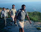
6 of the 7 Ramblers who ascended Mt. Lukens via the Stone Canyon trail on Saturday 12/6.
Despite a locked gate at the Wildwood Picnic gathering point assembled Bramblers were able to start up the Stone Canyon trail by 8:15 and summit between 10:15-10:45 AM.
Water level in Big Tujunga creek was low enough that we were able to scramble across without wading and we walked up the Stone Canyon wash until we located the trail to the west. Next time we'll go straight to the trail head - it's not a well marked as it could be!
The trail itself is partly shaded bu overhanging foliage and has a moderate incline. It's just rather long at 3.5 miles to gain the 3000' feet of elevation before coming out on the flat top of the mountain.
We're still waiting for Mike's GPS watch to dump its KML goodies. Look forward to that and photos from other Bramblers.
Next hike - Strawberry Peak on Saturday 12/20.
Sun on the final approach to the summit
November 26, 2008
Mt Lukens - Highest Point in LA City Limits

The Brand Ramblers hike Saturday December 6 to the highest point in Los Angeles city limits, Mt. Lukens at 5074 feet.
- Start Time: 7:30 AM, Saturday 12/6
- Trailhead: Wildwood Picnic Area in the Angeles National Forest (6 miles up Big Tujunga Canyon road from Sunland).
- Duration: Approximately 4-5 hours
- Distance: 8.5 Miles
- Elevation Gain: 3200 feet
- Total Elevation: 5074 feet
Checklist:
- Assemble at 7:30 AM at the Wildwood Picnic area. Plan to arrive early so we can start the trek on time. Cell phone reception in the Big Tujunga wash is terrible so you should not expect to call ahead about running late. Give yourself some extra time - you can use it to warm up and stretch before the hike.
- All cars will need a Angeles National Forest Adventure pass (either a day pass or annual pass). Day passes are $5 and Ken will be picking up passes at the Big 5 sporting goods store in Glendale on Friday - just let him know if you need one before noon Friday.
- To reach the Stone Canyon trail we need to cross the Big Tujunga creek which usually entails wading across. Removing your foot gear and rolling up pants works well but you might want to wear shorts to make this easier. Some Bramblers may bring trekking poles and these can be shared for the crossing.
- Gear: Good hiking shoes, hats, sun glasses, trek poles, etc. and dress in layers as it is expected to be chilly in the morning and warming up later in the morning.
- Food & Water: Bring at least 1-2 liters of water and some snack food. The usual suspects will be bringing extra snacks including smoked sausages to share.
- Car Pooling: Confirm your attendance by contacting Ken before Friday afternoon. If we can carpool we can save on the Adventure Passes and at least one USC area Brambler still needs a ride.
Some reviews of the hike:
LocalHikes.com
ModernHiker blog
November 25, 2008
Mt. Baldy Sets New 'Bramblers' Records

Early on Saturday November 22, 6 ramblers assembled at Manker Flats for an ascent of Mt. Baldy via the 'ski hut' trail and a return across the Devil's backbone. The 12 mile roundtrip include a punishing 4K foot climb to the summit.
This was the long planned ascent of Mt. Baldy and established a number of firsts for the Brand Ramblers: highest elevation (10054'); most elevation gain (3900'); longest distance (12 miles) and longest duration (6 hours).
What a gorgeous day! The weather was perfect and the views were spectacular the whole way. The alpine terrain was magical as we ascended the ski hut trail, continually changing as we passed through different elevations. The views from the Devil's Backbone were as advertised and allowed one to look north and west into the desert or south back to the city while navigating the narrow ridge line.
'Bramblers' associated with AT&T Interactive couldn't resist the temptation to celebrate the rebranding of Yellowpages.com and proudly posed for a summit shot.
The hike down the ski lift maintenance road was uneventful and a nice 'cool down' after the ascent. We got to observe some ambitious folks rappelling down the San Antonio Falls. Crazy!
(All photos courtesy of Sun)
September 30, 2008
Updates of Recent Hikes

We've been a little lax in updating the Brand Ramblers blog so we take this opportunity while cooling down from a Vital Link trek (see Google Earth image above looking down the ridge) to post the following updates:
Vital Link Weekly Fitness Hike, Tuesday 9/30
Mark, Sun, Ken, Chetan, Joel (first time to the summit for Chetan)
Mt. Lee/Hollywood Sign Hike Sunday 9/28
Neil, Angela, Vish & Ken (first time for Angela & Vish)
Vital Link Weekly Fitness Hike, Tuesday 9/23
Ryan, Sun, Ashish, Chetan, Joel (first time for Joel)
Vital Link Weekly Fitness Hike, Tuesday 9/16
Mark, Sun, Ryan, Julia, and Ken were returnees while Shri and Kevin were first-timers to the summit
Mt. Thom Sunset Hike (4th Ascent) Tuesday 9/9
Mark, Katya, Julia, Chetan, Ken (first time for Mark, Katya & Julia)
The days are rapidly getting shorter while the summer heat has been over staying its welcome. Look for more weekend outings and we'll be adapting by adding flashlights and headlamps as we continue our post-workday evening hikes.
On a sad note, we're losing Brambler Brother Harvey who's relocating to Atlanta and will be dearly missed on our treks. We wish him and his new family many happy hikes in the beautiful South East.
 |
| Harvey (far right) looks towards the camera as Brand Ramblers prepare to leave Fern Dell in Griffith Park, March 2008 |
September 27, 2008
Back to Mt. Lee & the Hollywood Sign
 |
The Brand Ramblers Tuesday evening Vital Link fitness hikes continue (2 down, 5 to go) although we may have to move the start to 5 PM given the rapidly shortening daylight.
Full updates and pics of recent hikes will be posted soon.
September 17, 2008
Weekly Fitness Hikes Kicked-Off
7 'Bramblers' kicked off the weekly Vital Link hike series last night with the successful completion of the 4-mile roundtrip from the Wildwood Canyon parking lot. Mark, Sun, Ryan, Julia, and Ken were returnees while Shri and Kevin were first-timers (Shri had made a previous descent during a traverse of the Verdugos but had never ascended the trail).
The weekly Vital Link fitness hike with continue on Tuesday through October 28.
The next Brand Ramblers weekend hike is the Sunday September 28 Mt. Lee/Hollywood Sign hike from Bronson Canyon. Details to follow... previous MT. Lee hike info is available here and here.
September 11, 2008
Weekly Vital Link Fitness Hikes - Tuesdays

As the cool weather returns the Brand Ramblers begin a weekly Vital Link fitness hike that will run until the end of October. Details to follow.
Mark Drapkin conquered Mt. Whitney a few weeks ago - as evidenced by the photo above.
September 5, 2008
Back to Mt. Thom for September Sunset
 |
Total roundtrip distance is approximately 5.5-miles with an elevation gain of 1200 feet. Park and assemble at the Las Flores Motorway gate (see driving directions for additional info). We’ll assemble at 5:30 and will start walking at 5:40.
The entire hike up and back should take about 1-1/2 to 2 hours. This is not a difficult trek if you are in reasonably good shape.
Driving Directions
From the intersection of Brand & Doran drive the 3 miles to the Las Flores Motorway trailhead.
- Head north (on either Brand or Central) and turn right onto East Glenoaks Blvd and drive for .7 mile
- See direction signs and turn right at the light to stay on Glenoaks Blvd as it takes a 90 degree turn – continue on another .1 mile to the intersection with N. Glendale Blvd.
- Turn left at N. Glendale Ave, staying in left lanes - continue on as Glendale Blvd becomes N. Verdugo Rd.
- Stay in the left lanes continue on N. Verdugo Rd. as it becomes Canada Blvd (follow signs for Canada Blvd)
- Continue driving north until you reach the end of Verdugo Park and turn left at Colina Drive.
- Continue up Colina Drive as it becomes Sunshine Dr.
- Locate street parking on Polaris Drive or on Sunshine Drive below the intersection with Sandingham Drive (watch for parking restrictions) and walk the rest of the way up Sunshine Drive to the Las Flores gate (just pass Kildonan Drive).
 |
View Larger Map
May 14, 2008
Mt. Thom Times 5
Despite a spate of last minute cancellations a small group of hardy Ramblers trekked up the Las Flores Motorway to Mt. Thom for yet another sunset hike. This was the first visit to the summit for the 4 pictured Ramblers (Shirley, Chetan, Ashish, and Vish), and the 5th for the cellphone photographer, Ken.
After days of "May Gray" (it's too early for "June Gloom") the weather turned out sunny and mild - perfect for this moderate walk. Still lots of clumps of gorgeous orange dodder and humming birds were busy enjoying the Monkey flowers which seem to be in full bloom.
Stay tuned for more Brand Ramblers hikes to be announced shortly. A return to Griffith Park is being planned to observe the first anniversary of the devastating 2007 brush fire and to examine the park's recovery.

May 8, 2008
Sunset Hike to Mt. Thom: Tuesday May 13

Please join the Brand Ramblers for another sunset hike as we return to Mt. Thom for a 3rd time this Tuesday 5/13 at 5:30 PM.
Total roundtrip distance is approximately 5.5-miles with an elevation gain of 1200 feet. Park and assemble at the Las Flores Motorway gate (see driving directions for additional info). We’ll assemble at 5:30 and will start walking at 5:40.
The entire hike up and back should take about 1-1/2 to 2 hours. This is not a difficult trek if you are in reasonably good shape.
Driving Directions
From the intersection of Brand & Doran drive the 3 miles to the Las Flores Motorway trailhead.
- Head north (on either Brand or Central) and turn right onto East Glenoaks Blvd and drive for .7 mile
- See direction signs and turn right at the light to stay on Glenoaks Blvd as it takes a 90 degree turn – continue on another .1 mile to the intersection with N. Glendale Blvd.
- Turn left at N. Glendale Ave, staying in left lanes - continue on as Glendale Blvd becomes N. Verdugo Rd.
- Stay in the left lanes continue on N. Verdugo Rd. as it becomes Canada Blvd (follow signs for Canada Blvd)
- Continue driving north until you reach the end of Verdugo Park and turn left at Colina Drive.
- Continue up Colina Drive as it becomes Sunshine Dr.
- Locate street parking on Polaris Drive or on Sunshine Drive below the intersection with Sandingham Drive (watch for parking restrictions) and walk the rest of the way up Sunshine Drive to the Las Flores gate (just pass Kildonan Drive).
|
View Larger Map
April 21, 2008
Cool Sunday: 'Bramblers' Embrace Henninger Flats

It was perfect weather for a hike and the overflowing parking lot at the Eaton Canyon Nature Center was proof enough. 12 'Bramblers' (plus Beckham, Anne's packdog) assembled a bit late but in good humor for the 3.1 mile trek up Walnut Canyon to the Mt. Wilson fire road that passes through Henninger Flats.
A big welcome to all the first timers - this was a solid 'moderate' hike with a nice pay-off at the decidedly cool summit.
The Brand Ramblers now go into a brief hiatus while we switch to planning mode for the next series of hikes. Expect an update within the next two weeks and an updated schedule.
Assembled 'Bramblers' pose in front of the fire lookout exhibit in Henninger Flats
April 15, 2008
Eaton Canyon to Henninger Flats Hike, Sunday 4/20, 8 AM

Please join the Brand Ramblers this Sunday morning (4/20) for a moderate 6.2 miles round trip hike up to forested Henninger Flats.
We'll meet up at the Eaton Canyon Nature Center in Pasadena at 8 AM Sunday morning and hike through the canyon taking the Walnut Canyon trail to reach the Mt. Wilson fire road that will take us on into Henniger Flats.
Eaton Canyon Nature Center [ Directions ]
1750 North Altadena Drive, Pasadena
Observe the usual preparations (water, appropriate shoes and clothing, snacks, sunscreen, etc). The weather is forecast to be very mild (low 60's) - perfectly hiking weather.
There is a 1600 foot gain in elevation for the 3 miles to the Flats but it's spread out enough with some variety so it's not particularly grueling.
View Larger Map
April 13, 2008
Up Across & Down - 'Bramblers' Boast Traverse
 |
6-hardy 'Bramblers' today inaugurated the Brand Ramblers annual Verdugo Traverse, enjoying gorgeous weather despite above average temperatures. While a higher attendance was anticipated no doubt distance (7-miles plus), elevation (1300 feet) and unexpected weekend heatwave helped suppress turnout.
 |
The north slope's thick, lush landscape was breath taking. Explosive clumps of sage, buckwheat, dodder, mustard, and smatterings of California poppies (as well as enormous stands of poison oak) abounded at every turn. Blackened stumps from previous brush fires were visible but were being rapidly overtaken by new verdant growth.
Views from along the Verdugo Motorway, the fire road that runs along the spine and is used to service the antenna farms. were also a surprise as the air quality was much better than one would expect given the mini-heatwave. The ocean was visible to the south west and one could look far into the Valley. Downtown Los Angeles stood out as an island to the south east and the now-drained Silver Lake reservoir was a surprise to see (beige instead of blue!).
The descent on the Vital Trail was harder than expected - it's a short, steep trail composed of numerous switchbacks with no opportunities to rest and water in shade. This was a bit of a grind but thankfully brief.
Since this was a longer trek than usual we had time to kick around ideas for future hikes and started initial planning for the Bramblers' Fall itinerary.
 |
Catching a bit of shade after descending Vital Link - ready for the last leg into Wildwood Canyon.
Next Hike: Eaton Canyon, Sunday 4/20, 8 AM
1st Annual Verdugo Tranverse - Sunday 4/13

Join the Brand Ramblers on Sunday as we make our first annual crossing of the Verdugos, starting from La Tuna Canyon in Tujunga Canyon, ascending up the Hostetter Motorway fire road to its junction with the Verdugo Motorway, leisurely strolling west along the spine and enjoying a rest stop at the Plantation Lateral before beginning a descent along the Vital Link trail into Wildwood Canyon where the trek ends and we pick up the assembled cars.
This should be a wonderful hike as we'll be spending time on the north slopes of the Verdugos where the landscape is much greener and the vegetation relatively lush compared to the north face. Weather permitting there should be some great views north and south as we move along across the spine between the clusters of aerials and rest near the Warden Grove.
View Larger Map
Overall hike is approximately 7 miles with an elevation gain of 1300 feet in the 3.4 mile ascent. This is a one-way trek so we'll meet at the Wildwood Canyon trail end at 8 AM to park the vehicles and then carpool to the La Tuna Canyon trailhead. We're expecting this to be a 3-4 hour hike depending on how quickly we assemble and kick-off and how much 'exploring' takes place along the way.
The weekend temperatures will be above season average so bring plenty of water, use sunscreen and wear protection from the sun. Bring some 'trail food' to eat and share when we rest at the Plantation Lateral.
April 9, 2008
Brand Sunset Scramble & 'Doddering'

An 8-strong contingent of the Brand Ramblers returned to the ridge trails behind the Brand Library (in Brand Park, Glendale) for a leisurely sunset hillwalk and scramble. Unfortunately not all were able to complete the 1.5 mile /1500 ft. change-in-elevation circuit but it was still a pleasant outing as weather was mild and the hillsides were green and bright with blooming flowers.
 |
"California dodder is a leafless, parasitic, viney plant with slender orange to yellowy stems which are each fastened to their host organism by means of a knobby root-like structure called a haustoria, which allows it to draw its nourishment from the host. If any leaves are present, they are minute and scale-like. The flowers are small, white, squat, urn-shaped, and arranged in loose cymose or paniculate clusters... Species californica, seems to be mostly partial to the buckwheats, sages, deerweed and Haplopappus. California dodder inhabits many plant communities from sea level to 8200' in most of cismontane California and occasionally on the deserts, and blooms from May to July"
- Source: Wildflowers and Other Plants of Southern California

Stay tuned for details of this Sunday's (April 13) Verdugo Traverse hike!
April 7, 2008
Brand Park Sunset Hike - Tuesday 4/8, 5:30 PM

We're headed back to Brand Park in Glendale for a short sunset climb up the foot path trail behind the Brand Library (see image above and map link below). We did the same hike last August and the weather this time promises to be much better!
The trail gets steep at several points (it follows a ridge leading up towards Mt Thom) but there are great views along the way and plenty of chances to stop and rest.
Meet at 5:30 PM at the Miss America Green Cross statue adjacent to the parking lot next to the Brand Library & Art Center inside Brand Park (1601 West Mountain Street, Glendale CA).
The entire hike up and back should take about 1-1/2 to 2 hours. There's a little bit of 'scrambling' at a few of the steeper parts of the trail but overall this is not a difficult trail if you are reasonably in shape.
Here's a Google map for the hike... see you there!
Driving Directions
To get to Brand Park from Brand Blvd - the simplest route is a 10-minute drive
- Go west on Doran towards Central Avenue
- Turn right heading north on N. Central Avenue crossing the 134 freeway and continuing 3 blocks until W. Glenoaks Blvd [.5 miles]
- Turn Left (left 2-lanes) onto W. Glenoaks Blvd and continue west [1.5 miles]
- Turn right on Grandview and head north until you come to Brand Park. [1.1 miles]
- Enter the park and park in the upper parking lot across from the Brand Library & Art Center
March 30, 2008
Rain Averse 'Bramblers' Melt Away, Miss Eaton

 |
A thick morning mist and threat of rain failed to deter one Brand Rambler (who shall remain nameless) from enjoying a brisk trek to the Flats - making the 6.2 miles round trip and 1600 foot elevation gain in just over 2-1/4 hours.
Visibility was severely limited but the hill hugging clouds made for a magical landscape as the trail snaked up to the forested flats.
Eaton Canyon-to-Henninger Flats truly is a wonderful and convenient weekend hike that promises great views - weather (and planning) permitting.
Next Hikes:
- Brand Park Sunset Hike Tuesday 5:30-7:30 PM, April 8
- Verdugo Traverse Sunday 8:00-11:30 AM, April 13
- Eaton Canyon-Henninger Flats Sunday 8:00-11:30 AM, April 27

March 28, 2008
Eaton Canyon - Henninger Flats - Sunday 3/30

Join the Brand Ramblers for our first San Gabriels hike. We'll meet up at the Eaton Canyon Nature Center at 8 AM Sunday morning 3/30 and hike through the canyon and up into Henniger Flats.
Eaton Canyon Nature Center [ Directions ]
1750 North Altadena Drive, Pasadena
Observe the usual preparations (water, appropriate shoes and clothing, snacks, sunscreen, etc).
Shirley will be 'walking point' on this excursion - you can call Ken on his mobile if you’re lost or running late.
March 27, 2008
Sunset on the Vital Link trail - Wed 3/26
5 hardy trekkers made a 1600 feet ascent up the Vital Link trail above Wildwood canyon in the 4th outing of March for the Brand Ramblers.
This popular trail was a good fitness challenge but we had to head back early because of waning light. We descended and walked out through Wildwood canyon park in the quickening darkness to complete the 4 mile hike in two hours.
Next hike: Sunday March 30, 8 AM
Eaton Canyon-Henniger Flats, Pasadena
Meet at the Eaton Canyon Nature Center at 1750 North Altadena Drive in Pasadena and we're hike up to Henniger Flats. More details to follow.
March 24, 2008
Wildwood Canyon Fitness Hike - Wed 3/26

 |
This hike is rated as a fitness hike as there is a nearly 1700 foot elevation gain in the 2 miles of the Vital Link trail that runs atop the western slopes of Wildwood Canyon to the junction with the Verdugo Motorway fire road. The trail is well maintained and has numerous switchbacks the last 3/4 mile as it rapidly ascends to the antenna complex at the summit.
Don't be put off – this isn't the stuff of Iron Triathlons – it's just a moderate-to-strenuous ridge trail that will give you an excellent workout while enjoying an early spring sunset!
Total round trip is 4 miles – and starting at 5:30 we should be back at the trail head by 7:30, just pass sunset.
Driving Directions
1. Take freeway (134 to 5) or surface streets to Harvard Road in Burbank and head north towards the Verdugo mountains.
2. Harvard Road enters parkland at Sunset Drive – continue north towards the Castaways and park in the lot at the junction with Wildwood Canyon road (the entrance is well marked). Do not park beyond the gate as it may be padlocked at sunset – instead park in the adjacent overflow lot.
3. We'll meet in the parking area and then head up Wildwood Canyon road to the first trail that takes one up to the ridge.
4. Call Ken's cell if you're running late or get lost.

March 20, 2008
Topped Off: Last Sunset of Winter 2007-08

The Brand Ramblers kicked-off the 2008 sunset hiking season with a 2.5 mile/1200 foot ascent of local favorite Mt. Thom in the Verdugo mountains.
 |
After a slight delay in gathering up the trekkers (thanks Kanwar!) we set off along the Las Flores Motorway fire road and reached the summit in just over an hour (with May, Shri and Wai dashing ahead).
Happy birthday to Ramblers Enrique and Hemant! Enrique celebrated his birthday this year by "bagging" Mt. Thom. Apologies to Leeand Matt for failing to alert them to this hike. We also really missed the company of Shirley, Vish, and Harvey!
Shri's photo gallery is now online - waiting for Wai and Enrique.
Next Hike: The Easter Sunday to Mt. Hollywood via Bee Rock and Mt. Bell has been postponed until April (see calendar for additional hikes and info). Check back soon for calendar updates.
Download this nice tabloid sized City of Glendale Trails and Fire Roads Map (PDF)

March 14, 2008
Sunset Hike: Return to Mt. Tom - Wed 3/19

Please join the Brand Ramblers as we head out for the first sunset hike of 2008 this Wednesday 3/19 at 5:00 PM. The entire hike up and back should take about 1-1/2 to 2 hours. This is not a difficult trek if you are in reasonably good shape.
Total roundtrip distance is approximately 5-miles with an elevation gain of 1200 feet. Park and assemble at the Las Flores Motorway gate (see driving directions for additional info). We’ll assemble at 5 and will start walking up Las Flores at 5:10.
Driving Directions
From the intersection of Brand & Doran drive the 3 miles to the Las Flores Motorway trailhead.
- Head north (on either Brand or Central) and turn right onto East Glenoaks Blvd and drive for .7 mile
- See direction signs and turn right at the light to stay on Glenoaks Blvd as it takes a 90 degree turn – continue on another .1 mile to the intersection with N. Glendale Blvd.
- Turn left at N. Glendale Ave, staying in left lanes - continue on as Glendale Blvd becomes N. Verdugo Rd.
- Stay in the left lanes continue on N. Verdugo Rd. as it becomes Canada Blvd (follow signs for Canada Blvd)
- Continue driving north until you reach the end of Verdugo Park and turn left at Colina Drive.
- Continue up Colina Drive as it becomes Sunshine Dr.
- Locate street parking on Polaris Drive or on Sunshine Drive below the intersection with Sandingham Drive (watch for parking restrictions) and walk the rest of the way up Sunshine Drive to the Las Flores gate (just pass Kildonan Drive).
|
March 9, 2008
Daylight Saved! Griffith Observatory Looped

 |
After ascending along the upper loop and spending some time exploring Observatory grounds (arrival was prior to the 10 AM opening) the Ramblers leisurely returned to Fern Dell by strolling down Canyon Drive to link up with the Western Canyon trail.
Plant/Shrub Watch: Kevin provided an updated ID for the Mountain or California Lilac (Ceanothus) that is now in bloom; Ken spotted a blooming California native Sacred Datura (Tolguacha) and as usual we saw lots of Castor Beans (Ricinus Communis), a source for an famous old-is-new-again poison.
Next Hikes:
Wednesday March 19 5 PM - Return to Mt. Thom in the Verdugo mountains. Full details to follow. See also last years BR hike to this local peak.
Sunday March 23 8 AM - Eaton Canyon to Henniger Flats in the San Gabriel Mountains (Pasadena).

March 5, 2008
Fern Dell to Griffith Observatory Hike - Sunday 3/9/2008

 |
Important Note: Daylight Savings returns Sunday morning at 2 AM - we 'lose' an hour of light in the morning so we pushed the start back to 8:30 AM. Daylight Savings means we can start after work hikes in the weeks to come - look for a return to Mt. Thom in the Verdugos on Wednesday March 19 (details to come).
Google map for the Fern Dell to Griffith Observatory hike
Driving Directions: Take Los Feliz Blvd to Fern Dell Drive (just east of where it turns into Western) and drive up Fern Dell into Griffith Park and find roadside parking across from the Trails concession stand (Trails makes a nice post hike treat - coffee and gourmet food). If you're running late or have trouble finding your way - call Ken.

March 2, 2008
13 to the Summit: Brand Ramblers Kickoff 2008 Season with Trek to Mt. Lee

The Brand Ramblers 2008 'season' kicked off with a pleasant Sunday 8 AM Griffith Park hike up Brush Canyon, across the Mulholland Trail to Mt. Lee and the Hollywood Sign. 13 brave ramblers made the 7-mile round trip that included a last minute leg to the Bronson Canyon 'Bat Cave.'
 |
Not counting the Bat Cave excursion the trek slightly exceeded the original estimate of 5-miles roundtrip and 90+ minutes. All told, it was a moderate if leisurely 180 minute effort involving an approximately 1100 foot gain in elevation.
More photo documentation to come from Karthik, Enrique and Harvey.
Next hike will be announced shortly - we expect to start afterwork evening hikes in the Verdugos once daylight savings returns on Sunday March 9.
UPDATE: Mary contributed these stats: 6.36 miles from the parking lot to the 'summit' and back; elevation gain just over 1100 feet; averaged 2.5 miles/hour, not counting resting time for snacks and water on Mt. Lee.
Enrique's Flickr album of this hike.
Karthik's Picasa album of this hike.

Subscribe to:
Posts (Atom)