Home away from home for hillwalkers and ramblers who happen to work together in a building in Glendale (and their family, friends and fellow ramblers). See the BR Event Calendar for upcoming hikes

March 30, 2008

Rain Averse 'Bramblers' Melt Away, Miss Eaton


A hastily planned Sunday morning excursion through Eaton Canyon up to Henninger Flats went off without a hitch and without hikers!

A thick morning mist and threat of rain failed to deter one Brand Rambler (who shall remain nameless) from enjoying a brisk trek to the Flats - making the 6.2 miles round trip and 1600 foot elevation gain in just over 2-1/4 hours.

Visibility was severely limited but the hill hugging clouds made for a magical landscape as the trail snaked up to the forested flats.

Eaton Canyon-to-Henninger Flats truly is a wonderful and convenient weekend hike that promises great views - weather (and planning) permitting.

Next Hikes:
  • Brand Park Sunset Hike Tuesday 5:30-7:30 PM, April 8

  • Verdugo Traverse Sunday 8:00-11:30 AM, April 13

  • Eaton Canyon-Henninger Flats Sunday 8:00-11:30 AM, April 27
Details to follow... see also the Brand Ramblers calendar below.

March 28, 2008

Eaton Canyon - Henninger Flats - Sunday 3/30


Join the Brand Ramblers for our first San Gabriels hike. We'll meet up at the Eaton Canyon Nature Center at 8 AM Sunday morning 3/30 and hike through the canyon and up into Henniger Flats.

Eaton Canyon Nature Center [ Directions ]
1750 North Altadena Drive, Pasadena

Observe the usual preparations (water, appropriate shoes and clothing, snacks, sunscreen, etc).

Shirley will be 'walking point' on this excursion - you can call Ken on his mobile if you’re lost or running late.

March 27, 2008

Sunset on the Vital Link trail - Wed 3/26


5 hardy trekkers made a 1600 feet ascent up the Vital Link trail above Wildwood canyon in the 4th outing of March for the Brand Ramblers.

This popular trail was a good fitness challenge but we had to head back early because of waning light. We descended and walked out through Wildwood canyon park in the quickening darkness to complete the 4 mile hike in two hours.

Next hike: Sunday March 30, 8 AM
Eaton Canyon-Henniger Flats, Pasadena
Meet at the Eaton Canyon Nature Center at 1750 North Altadena Drive in Pasadena and we're hike up to Henniger Flats. More details to follow.

March 24, 2008

Wildwood Canyon Fitness Hike - Wed 3/26


Please join the 
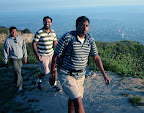
Brand Ramblers as we head out on a sunset fitness hike up Burbank's Wildwood Canyon to the Verdugo Moutains ridge line, this Wednesday 3/26 at 5:30 PM.

This hike is rated as a fitness hike as there is a nearly 1700 foot elevation gain in the 2 miles of the Vital Link trail that runs atop the western slopes of Wildwood Canyon to the junction with the Verdugo Motorway fire road. The trail is well maintained and has numerous switchbacks the last 3/4 mile as it rapidly ascends to the antenna complex at the summit.

Don't be put off – this isn't the stuff of Iron Triathlons – it's just a moderate-to-strenuous ridge trail that will give you an excellent workout while enjoying an early spring sunset!

Total round trip is 4 miles – and starting at 5:30 we should be back at the trail head by 7:30, just pass sunset.

Driving Directions
1. Take freeway (134 to 5) or surface streets to Harvard Road in Burbank and head north towards the Verdugo mountains.

2. Harvard Road enters parkland at Sunset Drive – continue north towards the Castaways and park in the lot at the junction with Wildwood Canyon road (the entrance is well marked). Do not park beyond the gate as it may be padlocked at sunset – instead park in the adjacent overflow lot.

3. We'll meet in the parking area and then head up Wildwood Canyon road to the first trail that takes one up to the ridge.

4. Call Ken's cell if you're running late or get lost.

March 20, 2008

Topped Off: Last Sunset of Winter 2007-08


The Brand Ramblers kicked-off the 2008 sunset hiking season with a 2.5 mile/1200 foot ascent of local favorite Mt. Thom in the Verdugo mountains.

This was also the last sunset of winter - which all enjoyed despite the somewhat smoggy air.

After a slight delay in gathering up the trekkers (thanks Kanwar!) we set off along the Las Flores Motorway fire road and reached the summit in just over an hour (with May, Shri and Wai dashing ahead).

Happy birthday to Ramblers Enrique and Hemant! Enrique celebrated his birthday this year by "bagging" Mt. Thom. Apologies to Leeand Matt for failing to alert them to this hike. We also really missed the company of Shirley, Vish, and Harvey!

Shri's photo gallery is now online - waiting for Wai and Enrique.

Next Hike: The Easter Sunday to Mt. Hollywood via Bee Rock and Mt. Bell has been postponed until April (see calendar for additional hikes and info). Check back soon for calendar updates.

Download this nice tabloid sized City of Glendale Trails and Fire Roads Map (PDF)

March 14, 2008

Sunset Hike: Return to Mt. Tom - Wed 3/19


Please join the Brand Ramblers as we head out for the first sunset hike of 2008 this Wednesday 3/19 at 5:00 PM. The entire hike up and back should take about 1-1/2 to 2 hours. This is not a difficult trek if you are in reasonably good shape.

Total roundtrip distance is approximately 5-miles with an elevation gain of 1200 feet. Park and assemble at the Las Flores Motorway gate (see driving directions for additional info). We’ll assemble at 5 and will start walking up Las Flores at 5:10.

Driving Directions
From the intersection of Brand & Doran drive the 3 miles to the Las Flores Motorway trailhead.

  1. Head north (on either Brand or Central) and turn right onto East Glenoaks Blvd and drive for .7 mile
  2. See direction signs and turn right at the light to stay on Glenoaks Blvd as it takes a 90 degree turn – continue on another .1 mile to the intersection with N. Glendale Blvd.
  3. Turn left at N. Glendale Ave, staying in left lanes - continue on as Glendale Blvd becomes N. Verdugo Rd.
  4. Stay in the left lanes continue on N. Verdugo Rd. as it becomes Canada Blvd (follow signs for Canada Blvd)
  5. Continue driving north until you reach the end of Verdugo Park and turn left at Colina Drive.
  6. Continue up Colina Drive as it becomes Sunshine Dr.
  7. Locate street parking on Polaris Drive or on Sunshine Drive below the intersection with Sandingham Drive (watch for parking restrictions) and walk the rest of the way up Sunshine Drive to the Las Flores gate (just pass Kildonan Drive).
Call Ken if you're running late or get lost. See Google map for this route.

March 9, 2008

Daylight Saved! Griffith Observatory Looped


Nine Brand Ramblers braved Sunday's early arrival of Daylight Savings for a brisk jaunt to the Griffith Observatory via the West Observatory trail. Wai kept himself busy collecting pixel-level documentation of the trek - see his gorgeous photo gallery.

After ascending along the upper loop and spending some time exploring Observatory grounds (arrival was prior to the 10 AM opening) the Ramblers leisurely returned to Fern Dell by strolling down Canyon Drive to link up with the Western Canyon trail.

Plant/Shrub Watch: Kevin provided an updated ID for the Mountain or California Lilac (Ceanothus) that is now in bloom; Ken spotted a blooming California native Sacred Datura (Tolguacha) and as usual we saw lots of Castor Beans (Ricinus Communis), a source for an famous old-is-new-again poison.

Next Hikes:

Wednesday March 19 5 PM - Return to Mt. Thom in the Verdugo mountains. Full details to follow. See also last years BR hike to this local peak.

Sunday March 23 8 AM - Eaton Canyon to Henniger Flats in the San Gabriel Mountains (Pasadena).

March 5, 2008

Fern Dell to Griffith Observatory Hike - Sunday 3/9/2008


Join the Brand Ramblers this Sunday at 8:30 AM as we regroup at Griffith Park's Fern Dell campground and hike up to Griffith Observatory. This trek is shorter than last week's Brush Canyon to Mt. Lee hike with less gain in elevation.

Important Note: Daylight Savings returns Sunday morning at 2 AM - we 'lose' an hour of light in the morning so we pushed the start back to 8:30 AM. Daylight Savings means we can start after work hikes in the weeks to come - look for a return to Mt. Thom in the Verdugos on Wednesday March 19 (details to come).

Google map for the Fern Dell to Griffith Observatory hike

Driving Directions: Take Los Feliz Blvd to Fern Dell Drive (just east of where it turns into Western) and drive up Fern Dell into Griffith Park and find roadside parking across from the Trails concession stand (Trails makes a nice post hike treat - coffee and gourmet food). If you're running late or have trouble finding your way - call Ken.

March 2, 2008

13 to the Summit: Brand Ramblers Kickoff 2008 Season with Trek to Mt. Lee


The Brand Ramblers 2008 'season' kicked off with a pleasant Sunday 8 AM Griffith Park hike up Brush Canyon, across the Mulholland Trail to Mt. Lee and the Hollywood Sign. 13 brave ramblers made the 7-mile round trip that included a last minute leg to the Bronson Canyon 'Bat Cave.'


Not counting the Bat Cave excursion the trek slightly exceeded the original estimate of 5-miles roundtrip and 90+ minutes. All told, it was a moderate if leisurely 180 minute effort involving an approximately 1100 foot gain in elevation.

More photo documentation to come from Karthik, Enrique and Harvey.

Next hike will be announced shortly - we expect to start afterwork evening hikes in the Verdugos once daylight savings returns on Sunday March 9.

UPDATE: Mary contributed these stats: 6.36 miles from the parking lot to the 'summit' and back; elevation gain just over 1100 feet; averaged 2.5 miles/hour, not counting resting time for snacks and water on Mt. Lee.

Enrique's Flickr album of this hike.

Karthik's Picasa album of this hike.