Home away from home for hillwalkers and ramblers who happen to work together in a building in Glendale (and their family, friends and fellow ramblers). See the BR Event Calendar for upcoming hikes

Showing posts with label mt thom. Show all posts

April 3, 2017

Back to the Beaudry Loop, Mt Tongva and Mt Thom


We're back on the trail as the days get longer and we're sticking to old favorites for the time being as people get back into shape.

Wednesday April 5, 2017 will be meeting at 5:15 PM the Beaudry Loop trailhead near 3110 Beaudry Terrace (accessed from Beaudry Drive and Country Club Dr. - see Google map link below).


More hikes to be announced soon.

March 16, 2010

Spring forward! Back on the trail... to Mt. Thom


Daylight Saving Time struck like a bolt of lightning - it's time to get back on the trail.

To keep things simply we'll be heading up to Mt. Thom this Thursday at 5:00 PM - a little earlier than usual (it may be PDT again but it'll still get dark fairly early).

Assemble at the parking area a block below the Las Flores gate and bring the usual gear (cider will be provided but you bring the water, sunscreen, etc). Since it'll start getting dark on the descent flashlights are recommended but may not be needed.

Previous Las Flores-to-Mt. Thom hike description with directions is here.

Lots of ambitious plans (again) for 2010 including Half Dome and the remaining peaks of the 'Big Three' - San Gorgonio and San Jacinto - and let's not forget Mt. Whitney.

But enough with the planning - let's hit the trail and share a toast atop Thom. See you there!


Last Bramblers' outing - resting on the Devil's Backbone.(PHOTO: Joel Scott)

May 10, 2009

May Sunset Hikes to Mt. Thom

Ken, Paul & Neil ascending the Las Flores motorway on the way to Mt. Thom
Twice weekly sunset 'conditioning' hikes are the order of the day for the month of May. The Monday Brand Library to Mt. Thom 'scramble' has proven a worthy alternative to the Vital Link workout and we'll continuing with regular weekly ascents through the rest of the month (excluding Memorial Day). Since this 'scramble' is so demanding we're also following up with a weekly easy-to-moderate Thursday trek up the Las Flores motorway (aka 'fire road') to Mt. Thom.
Steep section of the trail between the Brand Library and Mt. Thom
The final scramble just below the fire road

  • Mondays: Brand Library to Mt. Thom, 5:30-7:30 PM | Google Map
  • Thursdays: Las Flores Motorway to Mt. Thom, 5:30-7:30 PM | Google Map
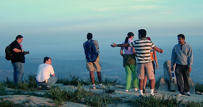
Bramblers atop Mt. Thom
Atop Mt. Thom with Glendale & Eagle Rock in the background
We're in the planning stage for a Monday Memorial Day hike - nothing too wild, and also looking at a return to Mt. Baldy in June.

May 14, 2008

Mt. Thom Times 5


Despite a spate of last minute cancellations a small group of hardy Ramblers trekked up the Las Flores Motorway to Mt. Thom for yet another sunset hike. This was the first visit to the summit for the 4 pictured Ramblers (Shirley, Chetan, Ashish, and Vish), and the 5th for the cellphone photographer, Ken.

After days of "May Gray" (it's too early for "June Gloom") the weather turned out sunny and mild - perfect for this moderate walk. Still lots of clumps of gorgeous orange dodder and humming birds were busy enjoying the Monkey flowers which seem to be in full bloom.

Stay tuned for more Brand Ramblers hikes to be announced shortly. A return to Griffith Park is being planned to observe the first anniversary of the devastating 2007 brush fire and to examine the park's recovery.

May 8, 2008

Sunset Hike to Mt. Thom: Tuesday May 13


Please join the Brand Ramblers for another sunset hike as we return to Mt. Thom for a 3rd time this Tuesday 5/13 at 5:30 PM.

Total roundtrip distance is approximately 5.5-miles with an elevation gain of 1200 feet. Park and assemble at the Las Flores Motorway gate (see driving directions for additional info). We’ll assemble at 5:30 and will start walking at 5:40.

The entire hike up and back should take about 1-1/2 to 2 hours. This is not a difficult trek if you are in reasonably good shape.

Driving Directions
From the intersection of Brand & Doran drive the 3 miles to the Las Flores Motorway trailhead.

  1. Head north (on either Brand or Central) and turn right onto East Glenoaks Blvd and drive for .7 mile
  2. See direction signs and turn right at the light to stay on Glenoaks Blvd as it takes a 90 degree turn – continue on another .1 mile to the intersection with N. Glendale Blvd.
  3. Turn left at N. Glendale Ave, staying in left lanes - continue on as Glendale Blvd becomes N. Verdugo Rd.
  4. Stay in the left lanes continue on N. Verdugo Rd. as it becomes Canada Blvd (follow signs for Canada Blvd)
  5. Continue driving north until you reach the end of Verdugo Park and turn left at Colina Drive.
  6. Continue up Colina Drive as it becomes Sunshine Dr.
  7. Locate street parking on Polaris Drive or on Sunshine Drive below the intersection with Sandingham Drive (watch for parking restrictions) and walk the rest of the way up Sunshine Drive to the Las Flores gate (just pass Kildonan Drive).
Call Ken if you're running late or get lost. See Google map for this route.


View Larger Map

March 20, 2008

Topped Off: Last Sunset of Winter 2007-08


The Brand Ramblers kicked-off the 2008 sunset hiking season with a 2.5 mile/1200 foot ascent of local favorite Mt. Thom in the Verdugo mountains.

This was also the last sunset of winter - which all enjoyed despite the somewhat smoggy air.

After a slight delay in gathering up the trekkers (thanks Kanwar!) we set off along the Las Flores Motorway fire road and reached the summit in just over an hour (with May, Shri and Wai dashing ahead).

Happy birthday to Ramblers Enrique and Hemant! Enrique celebrated his birthday this year by "bagging" Mt. Thom. Apologies to Leeand Matt for failing to alert them to this hike. We also really missed the company of Shirley, Vish, and Harvey!

Shri's photo gallery is now online - waiting for Wai and Enrique.

Next Hike: The Easter Sunday to Mt. Hollywood via Bee Rock and Mt. Bell has been postponed until April (see calendar for additional hikes and info). Check back soon for calendar updates.

Download this nice tabloid sized City of Glendale Trails and Fire Roads Map (PDF)